
Autumn has a way of sneaking up on us with crisp leaves and cozy evenings, but this year, it’s kicking off with a bang—or should I say, a howl. Enter Storm Amy, the very first named storm of the 2025-2026 season, barreling toward the UK and Ireland like it’s got a personal grudge against calm weather. If you’re in the northern reaches or planning a weekend getaway, this one’s got your name on it. Named by the Met Office just days ago, Storm Amy is more than a rainy blip on the radar; it’s a full-throated reminder that winter’s chill is just around the corner. In this post, we’ll dive deep into what Storm Amy means for you, from its explosive origins to survival tips that could save your bacon. Grab a cuppa, settle in, and let’s weather this storm together.
Understanding Storm Amy: The Science Behind the Fury
So, what exactly is Storm Amy, and why is it stealing the spotlight before the leaves have even turned fully gold? At its core, Storm Amy is a low-pressure system born in the restless Atlantic Ocean, where warm waters clash with chilly air masses high above. This isn’t your average squall—meteorologists are calling it a “bomb cyclone” because of how quickly it’s intensifying. Imagine a balloon inflating at super speed; that’s the pressure dropping faster than you can say “umbrella.” This rapid deepening, known as explosive cyclogenesis, happens when the jet stream—a high-altitude river of wind—gives the storm an extra turbo boost.
Drawing energy from the ocean’s lingering summer warmth, Storm Amy is expected to deepen dramatically as it approaches land. By Friday, October 3, its core could plunge to depths that unleash winds fiercer than a lion’s roar. Historical parallels? Think back to Storm Eunice in 2022, which left a trail of uprooted trees and flickering lights across southern England. Storm Amy might not be as widespread, but in its target zones, it’ll pack a similar wallop. The Met Office has already hoisted amber warnings, signaling that this storm isn’t messing around. It’s a classic example of how our warming planet is juicing up these weather events, making early autumn feel more like mid-winter mayhem. For those of us who love a good forecast drama, Storm Amy is the blockbuster we’ve been waiting for—but let’s hope it doesn’t require an evacuation sequel.
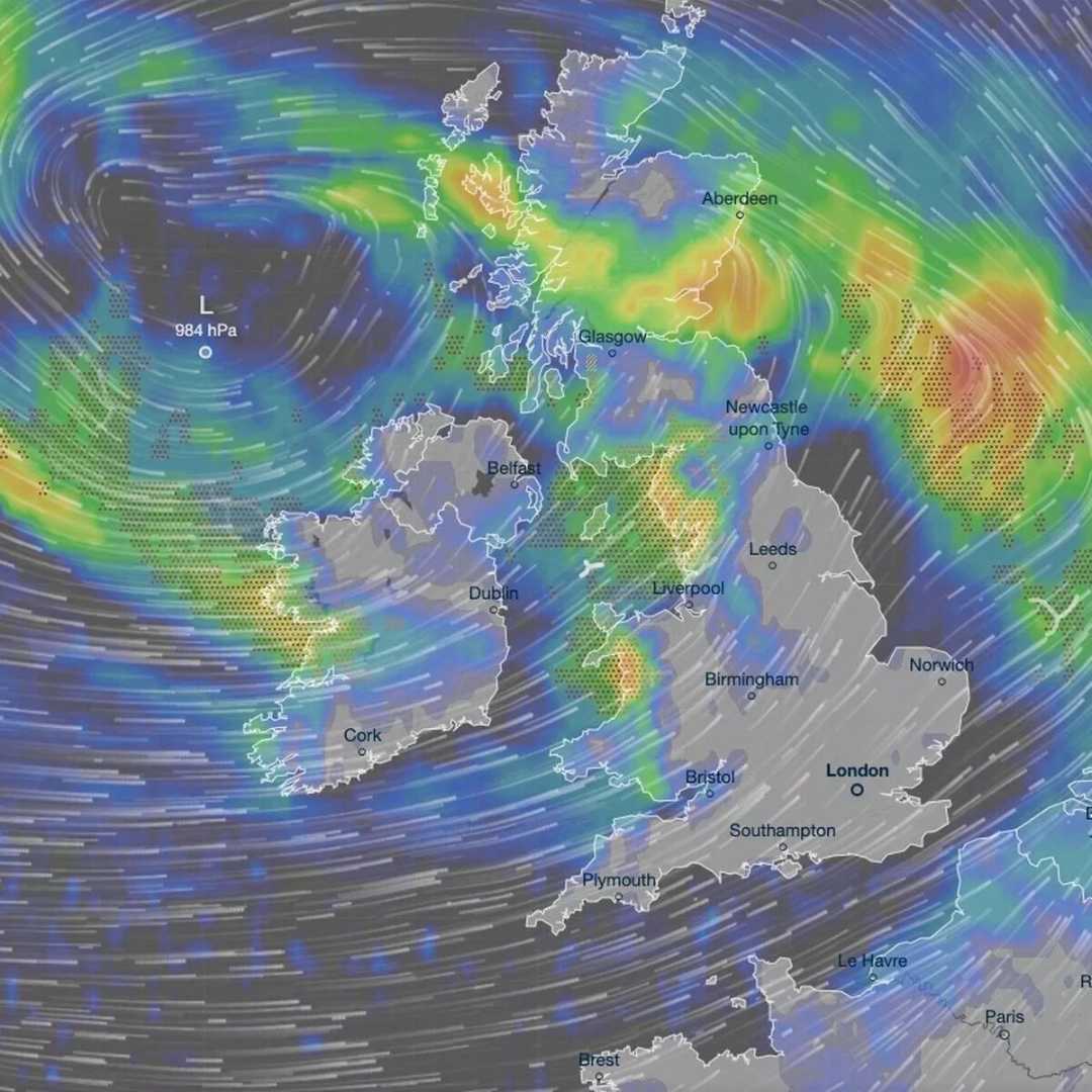
Storm Amy’s Path: Mapping the Mayhem Across the UK and Ireland
Timing is everything with Storm Amy, and right now, the clocks are ticking toward turbulence. The storm’s journey kicks off in earnest on Thursday evening, October 2, with the first whispers of rain and gusts tickling the western edges of Ireland and the northwest UK. But the real showstopper hits Friday afternoon, when Storm Amy makes landfall in western Ireland. Counties like Donegal and Mayo will bear the brunt first, with sheets of rain lashing windows and winds whipping up to 60-80 mph along the coast.
From there, Storm Amy charges eastward, crossing the Irish Sea and slamming into northern England and Scotland by late Friday. Northern England—think Cumbria, Lancashire, and the Lake District—will see the storm’s skirts brush by with 50-60 mph gusts, enough to rattle caravans and delay your pub lunch. But it’s Scotland where Storm Amy truly unleashes its wild side. The Highlands, Western Isles, and exposed northern coasts could face 70-100 mph blasts, turning coastal paths into no-go zones and sending debris dancing like confetti in a gale.
Saturday morning brings the peak for much of northern Britain, with Storm Amy lingering over eastern Scotland before finally petering out into the North Sea. By Sunday, the drama fades to blustery showers, but not before leaving a soggy trail. Yellow warnings blanket most of the north and west, while amber alerts scream “stay indoors” for Scotland’s wilder spots. If you’re plotting a hike in the Cairngorms or a ferry hop to the Hebrides, rethink it—Storm Amy has other plans.
The Dangers of Storm Amy: Winds, Waves, and Why It Matters
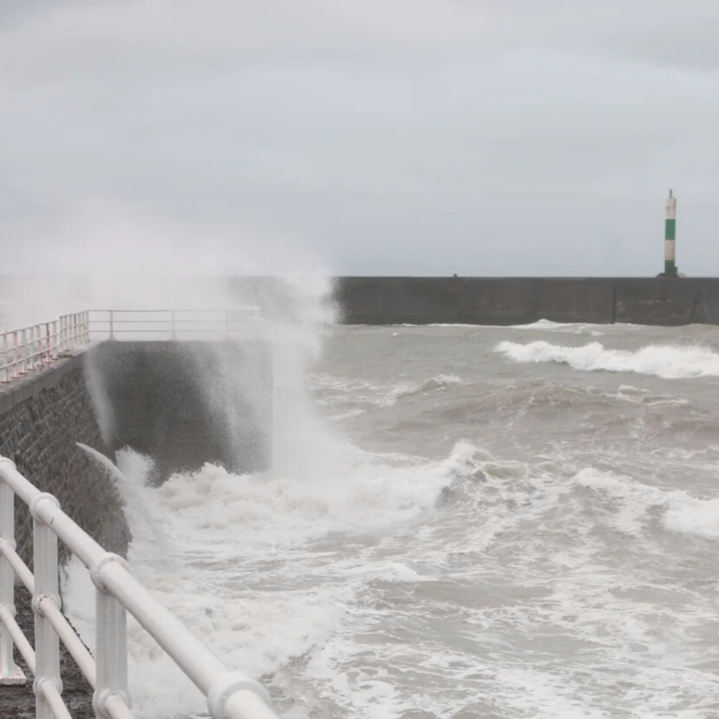
Don’t let the picturesque name fool you; Storm Amy is a force of nature with teeth. The headline hazard? Those ferocious winds. At 80-100 mph in the hottest zones, they can hurl roof tiles like frisbees, topple mature trees, and snap power lines like twigs. Coastal communities face rogue waves crashing 1-2 meters high, turning beaches into battering rams. Inland, it’s no picnic either—driving in 50 mph crosswinds feels like wrestling a shopping trolley in a hurricane.
Then there’s the rain: Up to 50mm could dump in just a few hours over western hills, sparking flash floods that turn country lanes into rivers. Combine that with poor visibility from sheeting downpours, and roads become skating rinks. Transport takes a hard hit—flights from hubs like Manchester and Glasgow might be grounded, trains crawl or halt amid debris, and ferries across the Irish Sea could bob indefinitely. Power outages? Expect thousands in the dark, especially in rural Scotland, where lines are more exposed than a hiker’s ankles in shorts.
But Storm Amy‘s ripple effects go deeper. For farmers, it’s a nightmare for livestock and late harvests; for coastal wildlife, surging seas disrupt habitats. And in a year of rising sea levels, every big storm chips away at our defenses. It’s a stark nudge to think about resilience—how one wild weekend can underscore the need for stronger sea walls and smarter planning.
Preparing for Storm Amy: Your Step-by-Step Survival Guide
Facing down Storm Amy doesn’t have to be terrifying if you’re armed with smarts. Start with the basics: Secure your surroundings. Lash down garden furniture, bins, and anything that could become a projectile—think satellite dishes or that wobbly trellis. If you’re coastal, consider boarding windows against flying shrapnel.
Stock up like it’s the apocalypse lite: Torches, spare batteries, a full kettle, and non-perishables for at least 24 hours. Charge every device—phones for alerts, laptops for Netflix if the power holds. For flood risks, elevate valuables and know your escape routes; apps like Floodline can ping you with warnings.
Travel? Only if you must. Check rail and flight apps obsessively, and if you’re driving, pump the brakes early—wet leaves plus wind equals wipeouts. Families with kids or pets: Designate a safe room away from windows, and have games or books ready for indoor marathons. And don’t forget the mental prep—storms like Storm Amy can spike anxiety, so a deep breath and a weather radio go a long way.
Local councils are on alert too, clearing drains and monitoring hotspots. Tune into BBC Weather or the Met Office app for real-time intel—their color-coded maps are equal parts informative and ominous.
After Storm Amy: Clearing Skies and Lessons Learned
Once Storm Amy blows through on Saturday, the UK wakes to a scrubbed-clean feel: Cooler temps in the 10-14°C range, with northwesterlies ushering in crisp air and scattered showers. Sunday offers a breather—brighter spells in the south, though the north stays damp. Looking ahead, early next week holds a westerly pattern: More rain in the northwest, but drier days in the southeast with highs nudging 16°C.https://gb.news/millions-of-uk-homes-urged-to-stock-up-on-batteries-by-friday/
By mid-October, high pressure from the Azores promises calmer vibes—misty mornings, golden sunsets, and a storm hiatus. It’s nature’s way of saying, “Whew, that was intense—let’s chill.” But Storm Amy leaves takeaways: Climate chats will buzz anew, and we’ll all appreciate a quiet cuppa more.
In the end, Storm Amy is autumn’s opener, a thrilling (if soggy) prelude to the season. Stay vigilant, stay connected, and remember: We Brits are built for this. What’s your go-to storm snack? Share in the comments—let’s swap stories while the wind howls. Safe sailing, friends!Arts and Entertainment